Partnering with uAvionix to add ADS-B Integration
Event 38 Unmanned Systems Partners with uAvionix to Improve Airspace Safety for Manned and Unmanned Aircraft
Akron, Ohio—March 6, 2019—Event 38 Unmanned Systems announced today that it has entered into a collaborative agreement with uAvionix to resell and integrate uAvionix ADS-B products with Event 38 aircraft.
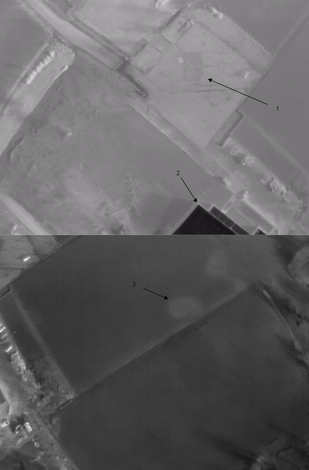
Unmanned aerial systems and manned aircraft equipped with uAvionix ADS-B transceivers can track each other electronically while in flight. ADS-B transceivers like the Ping2020, which is small enough for Event 38 drones, receive and transmit information about air traffic such as location, altitude, and speed. The Ping series can detect ADS-B messages from aircraft up to 100 miles away.
When a uAvionix ADS-B transceiver is integrated with an Event 38 aircraft, operators can see the locations of manned air traffic overlaid directly on their ground station display. This capability improves both operator and pilot situational awareness, so operations near manned aircraft can be performed with an added level of safety. This risk mitigation tool may also increase the chance of being approved for Part 107 waivers such as high altitude and BLOS operations, depending on the location and airspace of the operation.
With this added ADS-B capability, Event 38 aircraft continue to lead the industry in long range mapping aircraft for EVLOS and BLOS operations. “Our prediction is that the FAA will require ADS-B as part of its eventual integration of unmanned aircraft into the NAS,” says Jeff Taylor, President, Event 38. “By partnering with uAvionix to offer this capability, we hope to make it easier for our customers to obtain Part 107 waivers now and to build flight heritage for future changes in regulation.”
Event 38 will carry all of uAvionix’s products for unmanned aircraft, including Ping2020, Ping1090, Ping200S(r) Transponders, and PingUSB. These products will be available on all Event 38 long endurance aircraft starting with the E384-Heavy and E400.
To learn more, get in touch with Jeff Taylor at jeff@event38.com or visit www.event38.com.
About Event 38 Unmanned Systems
Founded in 2011, Event 38 Unmanned Systems operates out of Akron, Ohio, and has customers all over the world. Event 38 designs and manufactures long range drones, onboard data processing solutions, and other equipment for unmanned aerial systems.