Event 38 & Embrapa Conduct Joint Research
In association with Bird Eye Drone Services of Brazil, Event 38 and Embrapa begin join research for using drones on Brazilian farms.
Read more about the partnership on Embrapa News.
In association with Bird Eye Drone Services of Brazil, Event 38 and Embrapa begin join research for using drones on Brazilian farms.
Read more about the partnership on Embrapa News.
Akron, Ohio – Event 38, a leading business drone solution provider, opened pre-orders for the E384-LR Long Range Mapping Drone. The E384-LR is a special configuration of the popular mapping drone, the E384. Incorporating a light-weight and high resolution Sony QX-1 camera with state of the art battery technology, the E384-LR can achieve a useful flight time of 110 minutes, covering as much as 2,100 acres (850Ha, 3.3sq mi) at a resolution of 5cm/pixel in a single flight. The E384-LR is expected to begin shipping on December 5th.
Jeff Taylor, CEO of Event 38, says, “Our customers depend on the E384 to produce aerial imagery of large areas from farms in Iowa to the most remote and inhospitable corners of 6 continents. By flying even longer, the E384-LR lets our customers spend less time swapping batteries and more time collecting data.”
Starting at just $4,298 for a complete drone mapping system including sensors and flight software, the E384-LR is also a very economical platform to acquire and maintain.
To see more options and check pricing, select the E384-LR configuration on the E384 product page.
About Event 38 Unmanned Systems: Based in Akron, Ohio, Event 38, www.event38.com designs and manufactures drones, (unmanned aerial systems), specialized optical sensors, and a precision analytics data platform for small and medium sized businesses. Today we have customers in 49 countries using our products for agriculture, surveying, construction, environmental preservation, and other applications.
The Drone Data Management System™ officially starts accepting ground control points as of today. Ground control points are used in situations where high accuracy, on the order of centimeters, is required for a map. They allow drone maps to be used for critical work in surveying, construction, agriculture and other industries.
Learn more about the Drone Data Management System™ or read how to start using your GCP data now.
Ground control points are billed on a per-use basis and are available only to users in the DDMS™ Advanced tier, please contact us for more information.
Two new tools are now available to all Drone Data Management System™ users. As part of the Map Viewer data analysis suite, users will now see a legend appear next to maps where an underlying data layer is present. NDVI, DVI and DEM layers show their scale of values and corresponding colors for easy interpretation of each layer. In addition, for the NDVI and DVI layers, clicking on the map at any location will also reveal a popup with GPS coordinates and exact data values.
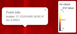
These features are automatically available to all users processing NDVI, DVI or DEM data.
Recently, we discovered that the Ecuadorian organization Drone & GIS has been using our E384 fixed-wing drone for quite the unique and amazing application; saving the spider monkeys. The Brown-headed Spider Monkeys are a critically endangered species, and efforts for their preservation and well-being have been ongoing. By flying our E384 over an area of the forest of about 1200 hectares, Drone & GIS was able to quickly and efficiently discover which areas of the forest are habitable for the continued well-being of the spider monkey. You can view the full article here.