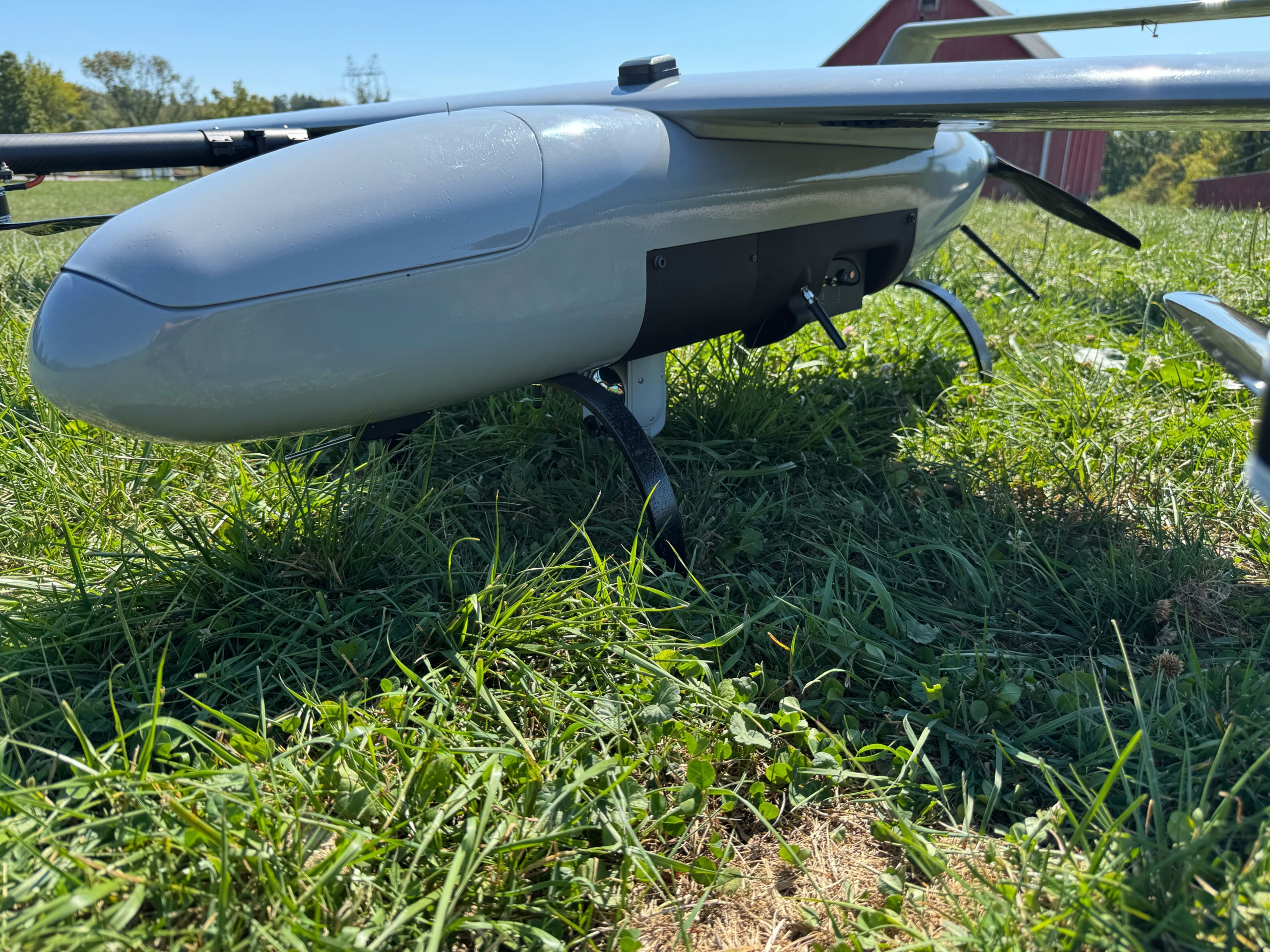
Event 38’s E455 Supports U.S. Army Training Exercise in Alaska

Event 38 Unmanned Systems recently wrapped up a live operational demo in Alaska, where the company’s E455 VTOL fixed-wing drone supported a U.S. Army training exercise in extreme winter conditions. The flight event showcased the aircraft’s ability to deliver real-time video, extend communications, and plug directly into TAK-enabled workflows used by soldiers in the field.

The exercise placed teams in a remote, rugged environment with a defended stronghold as the objective. In the scenario, the “Blue Team” conducted a parachute insertion from a C-130 into an undisclosed location and began moving toward the target area. After the jump was complete and the airspace was cleared, Event 38 launched the E455 to provide persistent overwatch around the perimeter.

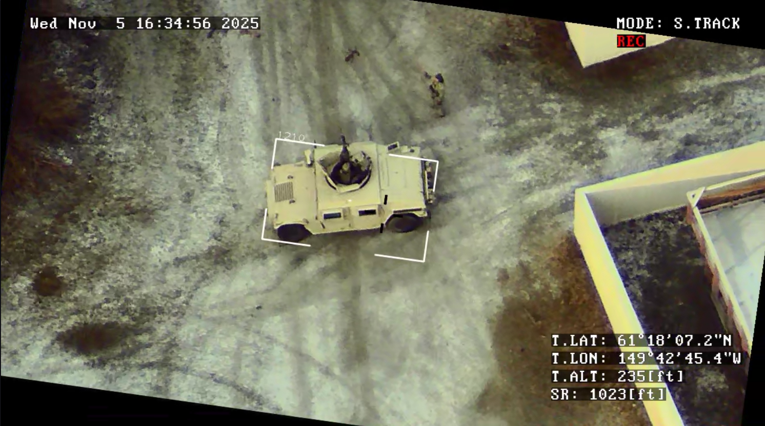
Our E455 Drone was tracking Blue Team’s movement within minutes of takeoff. The E455 streamed live multicast video which was complete with embedded GPS metadata through onboard Silvus networking hardware. The feed was distributed to multiple users at once, including WinTAK devices inside the Tactical Operations Center, soldiers’ mobile devices at the stronghold, and mortar fire positions.

ATAK also displayed the UAS position and gimbal crosshair target coordinates, helping speed up fire mission processing while improving situational awareness across the network.

To push communications even farther, Event 38 added an additional TSM radio inside the aircraft alongside the Silvus radio. This configuration expanded range on the Army’s TSM network while maintaining connectivity on the Silvus network.

Alaska’s weather did its best to make things difficult. The E455 operated through night flights, snow, humidity, and icing conditions in temperatures down to –4°F. Despite the environment, the system maintained stable performance and reliable delivery of sensor data throughout the exercise.

The aircraft flew with a NextVision Raptor payload, providing both EO and thermal imaging. That combination allowed operators to track targets in low visibility and challenging terrain.

“Operating alongside the Army was an eye-opening demonstration of just how impactful our technology can be on the modern battlefield,” said Mat Wright, Event 38’s Vice President of Engineering and Operations. “Beyond employing the aircraft as an offensive capability, we were able to expose soldiers to the kinds of systems they may face in future conflicts—helping them better prepare for what’s coming. As a smaller company, we often see large-scale demonstrations conducted by organizations like Anduril and Edge Autonomy and know we’re capable of meeting those same challenges. This effort marked a meaningful step in that direction, carried out in one of the most challenging environments in the world.”

For Event 38, the Alaska demo reinforced what the E455 is built for: rapid deployment, modular payload integration, long-range connectivity, and dependable ISR in tough operating conditions.

Event 38 Integrates CENTUM’s Lifeseeker Mini S10 on the E455 Heavy-Lift VTOL Platform

Event 38 Unmanned Systems and CENTUM have completed the integration of the Lifeseeker Mini S10 system on Event 38’s E455 fixed-wing VTOL platform—delivering a powerful new capability for public safety, search and rescue, and mission-critical operations.

CENTUM, a product-driven company specializing in airborne technology based on mobile phone systems, developed Lifeseeker Mini as an airborne solution designed to help locate missing persons by geolocating cell phones—even in areas without network coverage. With its optimized size, weight, and power (SWaP), Lifeseeker Mini is engineered for seamless integration into drone platforms like the E455, enabling fast deployment and greater operational effectiveness in complex environments.

Expanding Mission Capability for Public Safety Agencies

Based in Richfield, Ohio, Event 38 Unmanned Systems designs and manufactures high-performance fixed-wing VTOL drones for commercial, government, and public safety customers worldwide. Since 2011, Event 38 has delivered advanced unmanned aircraft systems that capture precise, geo-tagged data to support a wide range of missions across multiple industries.

Event 38’s flagship platform, the E455, is a heavy-lift, long-endurance fixed-wing VTOL drone engineered for intelligence, surveillance, and reconnaissance (ISR), high-precision mapping, and critical infrastructure inspection. With extended flight times, secure communications, and support for advanced payload integrations, the E455 is uniquely built to meet the demanding needs of public safety and government operators around the world.

With the Lifeseeker Mini S10 now integrated, the E455 expands its mission versatility—bringing a new layer of capability to teams working to locate missing persons and respond faster in time-sensitive situations.

Built for the Realities of the Field

“This integration underlines the adaptability and mission-readiness of Lifeseeker Mini,” said Javier Chamorro, President at CENTUM. “It reinforces our commitment to making life-saving technology available through trusted, proven unmanned systems.”

“The E455 was built to support missions where reliability and capability can make all the difference,” said Jeff Taylor, CEO and Founder of Event 38. “By integrating the Lifeseeker system, we’re giving responders the ability to locate missing persons faster and operate more effectively in the field. It’s an example of how we listen to our customers and deliver solutions that truly meet their needs.”

Learn More

To learn more about the E455 platform and its mission-ready payload capabilities, contact Event 38 Unmanned Systems at sales@event38.com

Event 38’s E455 Drone Supports Los Alamos Researchers in Locating Oil and Gas Wells

Event 38’s E455 Drone Supports Los Alamos Researchers in Locating Oil and Gas Wells

A Smarter Way to Find Hidden Oil and Gas Wells

Across much of the United States, remnants of early oil and gas development remain scattered beneath the landscape. Many wells were drilled decades ago, before modern mapping and reporting standards existed. Some were poorly documented, others never recorded at all. Over time, they were abandoned, overgrown, or buried under farmland—out of sight, but not without risk.

These forgotten wells can still leak methane or contaminate groundwater, creating environmental and safety concerns that are difficult to address when their locations are unknown.

Finding them isn’t easy. Historical records are often incomplete, terrain can be remote or difficult to access, and traditional ground surveys are time-consuming, expensive, and sometimes unsafe. To overcome these challenges, researchers at Los Alamos National Laboratory (LANL) are combining artificial intelligence with aerial data collection, using drones to turn predictions into verified locations.

Turning AI Predictions into Confirmed Sites

The effort begins with machine learning. LANL researchers analyze historical well records, geological data, and spatial patterns to identify areas where undocumented wells are most likely to exist. While these models help narrow the search, predictions alone aren’t enough. Confirmation requires real-world data collected directly from the landscape.

That’s where aerial surveying plays a critical role.

Using Event 38’s E455 VTOL fixed-wing drone, researchers can fly precise, low-altitude survey patterns over large areas. The aircraft is equipped with high-sensitivity magnetometers. These sensors are designed to detect subtle magnetic disturbances in the ground. These anomalies often indicate buried steel well casings or other subsurface infrastructure.

Collecting this data from the air allows researchers to confirm potential well locations without disturbing the terrain or relying on extensive ground access.

Why Airborne Surveys Make the Difference

Wide-area magnetometer surveys have traditionally been difficult to scale. Ground-based surveys require significant time and manpower, and many sites are simply inaccessible. Manned aircraft can cover ground more quickly, but they’re expensive and often can’t fly low enough to capture the level of detail required for this kind of work.

“The ability to perform wide-area magnetometer surveys from the air hasn’t been practical at scale until recently,” said Jeff Taylor, Founder and CEO of Event 38. “With the E455, researchers can identify lost wells, unexploded ordnance, and other buried anomalies in areas that would otherwise be impossible or unsafe to access.”

The E455’s hybrid design—combining vertical takeoff and landing with efficient fixed-wing flight—allows it to operate from remote launch sites while still covering large areas efficiently. Its modular payload system lets researchers customize sensor configurations for each mission, and its long-range communications and extended endurance support the collection of high-quality data across challenging terrain.

Event 38 Featured in World Pipelines Magazine

Event 38 Unmanned Systems is excited to share that our E455 drone was recently featured in World Pipelines magazine. The article showcases how the E455 is advancing BVLOS capabilities for pipeline inspections.

This recognition in a leading international publication highlights the growing role of drone technology in infrastructure monitoring and positions Event 38 at the forefront of the next generation of utility inspection solutions.

You can read the full feature on page 101 in the August edition of World Pipelines here: World Pipelines – August 2025 – Page 101

EVENT 38 ANNOUNCES SUCCESSFUL BVLOS PIPELINE INSPECTION DEMO WITH  FIXED-WING VTOL DRONE 

(Richfield, Ohio) – February 12th, 2025 – Event 38 Unmanned Systems, a leading manufacturer of American-made mapping drones, announces that a successful BVLOS pipeline patrol demo has been completed using the E455, Event 38’s largest fixed-wing vertical takeoff and landing (VTOL) drone. The E455 flew 320 miles in just under 7.6 flight hours. The demo was executed by Phoenix Air Unmanned (PAU), a drone service provider that specializes in aerial inspection and surveillance for utilities. 

The demo was a proof-of-concept exercise to determine whether PAU could achieve the goal of patrolling 300 miles of pipeline, owned by Shell Pipeline Corporation, with a drone in just one day. “We woke up to a two-hour delay with fog, so we crossed the 300-mile mark at noon on the second day,” said Will Wheeler, Director of Operations, Phoenix Air Unmanned. “But our goal was achieved within a day of flying time, so it was a success.” 

Event 38 trained a team of six PAU pilots in just three days and integrated the E455 into PAU’s existing command control stations in less than a week. The demo was completed the following week. 

Wheeler credits much of the demo’s success to the user-friendly design of the E455. “Ease of use and reliability is a big deal for us. We have the foundational knowledge of how to execute BVLOS flights at scale, however we had never flown the E455 before,” he said. “We received training, the E455 was integrated, and then we were out there doing 300 miles. What will we be capable of once our whole crew has experience with this platform and it’s truly integrated into our workflow? It’s repeatable and scalable.” 

For the purposes of the demo, the E455 was outfitted with an Iris Casia 3-camera system, which is critical for BVLOS missions, two redundant radio links, and an ADS-B in, in addition to a standard live gimbaled camera. Drone communications were handed off between three ground control vans to increase efficiency, and ground control received a constant live video feed from the E455’s on-board cameras. Thanks to the E455’s bonded radio solution, the drone never lost signal with PAU. 

Even with the abundance of equipment required for a BVLOS mission, the E455 flew for up to sixty minutes on a single charge. With a standard payload, the E455 can fly for over two hours on a single charge. In optimal conditions, the E455 can travel at 50 miles per hour. speed is 50 miles per hour in optimal conditions. 

“This demo was an excellent opportunity for us to learn more about how the E455 operates in real-world scenarios and make some other modifications that will translate to a better user experience going forward,” said Mathew Wright, VP of Engineering and Operations, Event 38. 

About Event 38 Unmanned Systems: 

Event 38 designs and manufactures fixed-wing VTOL drones in Richfield, Ohio. Since 2011, we’ve sold over 500 drones to people and organizations all around the globe. Our drones capture geo-tagged data for a range of industries and applications. Event 38 drones can be customized for high-resolution aerial photogrammetry, thermal and multispectral imagery, LiDAR, and live video streaming.

Event 38 Unmanned Systems Teams Up with AviSight in Selecting Elsight’s BVLOS Connectivity Solution

Elsight’s BVLOS Connectivity Solution: Achieving Precise Data Collection

Event 38 Unmanned Systems Teams Up with AviSight in Selecting Elsight’s BVLOS Connectivity Solution to Achieve Precise Data Collection in its Oil and Gas Pipeline Inspections over Difficult Terrain

June 13, 2024 – Leading manufacturer of unmanned aerial vehicles Event 38 and AviSight, a provider of critical infrastructure inspections, announced the use of Elsight’s Halo, an AI- based UAV connectivity solution, to enable beyond the visual-line-of-sight (BVLOS) inspections with precise data collection in extensive oil and gas pipeline inspections over difficult terrain.

At the heart of this collaboration is Elsight’s Halo, a lightweight, highly reliable communications system. Halo’s AI-based software aggregates multiple IP links to a secure bond using public and private cellular, satellite, and RF technologies ensuring uninterrupted drone communications even in the most challenging environments. Whether it’s disaster response, surveillance, deliveries or lengthy remote inspections, UAV (uncrewed aerial vehicle) flights powered by the Elsight Halo complete the mission with continuous transmission of high-bandwidth video and data to the command-and-control center (C2).

When facing the operational and economic challenges of data collection from major pipelines, AviSight’s CEO, Suzanne Herring, was quite rigorous in her selection of the optimal VTOL drone and the BVLOS connectivity solution for these missions and required connectivity with the highest bandwidth, lowest latency, highest redundancy, and of course, the most reliable link.

“AviSight’s reputation is dependent on our ability to provide accurate, timely and consistently critical infrastructure inspections through the use of unmanned ariel systems in a cost-effective manner. In a technology market that is rapidly developing, it is essential to remain innovative in our systems methodology while also embodying the challenges of an efficient execution of the mission. With C2 linkage being a primary priority for our BVLOS missions, it was essential to find a partner with the capabilities to maintain communications throughout our volatile terrains. Elsight has provided us with the ability to maintain C2 through vast wetlands, mountainous regions, and remote areas. While Event 38’s E455 has given us the ability to fly extensive linear inspections efficiently and more cost effectively,” said CEO of AviSight, Suzanne Herring

“We sought the right combination to maintain command and control over more than 2,000 miles of pipeline inspections in a variety of terrains. Event 38 and Elsight enabled us to overcome terrain and distance challenges and provide precise data to our customers ensuring their regulatory compliance,” added Herring

Event 38 Unmanned Systems latest VTOL, the E455 is a premier fixed wing, vertical takeoff and landing (VTOL) drone. At just under 55lbs, the E455 offers a 2 hour flight endurance on battery power alone. The E455 is designed to carry a diverse range of payloads, including mapping sensors, LiDAR, and EO/IR surveillance sensors, meeting the strict demands of various applications such as lengthy pipeline inspections.

“The high bandwidth and low power usage of the Elsight Halo paired with the E455 open endless possibilities of inspections over long distances and rugged terrain that were not possible previously,” said Jeff Taylor, CEO of Event 38 Unmanned Systems. “Our E455 VTOL was able to get closer to the pipelines with the help of Elsight.

“Working with Event 38 and AviSight has been very fulfilling from both technological and business perspectives. Our Halo was designed for mission-critical goals, particularly, in difficult situations,” said Yoav Amitai, CEO of Elsight. “Elsight optimizes the use of drones in many industries with reliable BVLOS connectivity for operational effectiveness. At the same time, we enable industry growth by using only one operator to control a drone fleet from remote locations anywhere. This is how we see our Halo as a market catalyst for drones in pipelines, and inspections in many industries, in which removing the human element delivers better and safer results.

About AviSight

AviSight provides industrial inspections of critical infrastructure and advanced data solutions for regulatory compliance, asset management, and predictive maintenance. We work with fortune one hundred partners in all verticals of critical infrastructure including Power, Gas, Oil, Telecom, and Transportation. Our mission is to create a generational paradigm shift in data collection and actionability that increases safety exponentially while achieving significant cost savings for our clients. We have been working with our partners and customers on legislative activity and regulatory expansion to ensure the ability to create BVLOS programs that will help take inspections into the 21st century.

About Event 38 Unmanned Systems

Established in 2011 and with customers all over the world, Event 38 Unmanned Systems is a leading provider of Unmanned Aircraft Systems (UAS). Our customers use their drones in diverse fields including Security, Surveying, and Environmental Conservation. Our hybrid fixed wing VTOL aircraft offer an extended endurance capability for covering dozens of miles or hundreds of acres. With a variety of payload options and customizable solutions available, our aircraft collect thermal, multispectral and high-resolution imagery and with centimeter-level geotagging accuracy.

About Elsight

Elsight (ASX:ELS) Elsight delivers Connection Confidence with proprietary bonding connectivity that incorporates both software and hardware elements to deliver reliable, secure, high bandwidth communications – even in the most challenging areas for stationary, portable, or actively mobile situational requirements. Elsight provides robust, secured connectivity to unmanned aerial and ground systems manufacturers, operators, and integrators globally.

Event 38 Unmanned Systems Introduces 360 Degree Camera Integration on Latest E400 ISR Drone

(Richfield, Ohio) – April 3rd, 2024 – Event 38 Unmanned Systems, a leading manufacturer of American-made VTOL fixed-wing drones, is pleased to announce the integration of a 360-degree camera option on its flagship E400 fixed-wing VTOL ISR drone.

Partnering with NextVision, a renowned provider of stabilized cameras and accessories for commercial and industrial applications, Event 38 now offers a range of EO/IR Gimbal camera options for seamless integration with the E400 drone platform.

NextVision’s gimballed EO/IR cameras boast field-proven technology, capturing high-quality visual and thermal imagery and video. These cameras enable live streaming directly to ground stations, providing operators with continuous monitoring capabilities.

The incorporation of a 360-degree EO/IR camera onto the E400 ISR platform enhances its effectiveness in various scenarios, including search-and-rescue missions, suspect pursuit, emergency management, and disaster response, such as swift water rescue operations. Now, customers have the ability to keep the target in sight at all times in flight. The E400 ISR, built with a military-grade carbon fiber frame, offers exceptional durability for rugged field applications. Moreover, its extended endurance allows for extended flight durations without the need for frequent recharging, enabling extensive coverage in a single flight.

This latest integration is particularly suited for surveillance and security applications, leveraging the E400 ISR’s electric propulsion and minimal noise emissions for discreet flight operations.

“The ability to rotate the camera indefinitely means an operator will never find themself limited in choosing what angle from which to observe a target,” said Jeff Taylor, Founder and CEO of Event 38. “In rapidly evolving situations it is critical to keep the target in sight at all times, and this 360 rotation capability allows just that on the E400-ISR.”

Event 38 will be showcasing the E400 ISR at various Public Safety conferences and upcoming events in the near future.

For more information about Event 38 and its range of mapping drone solutions, please visit www.event38.com.

Event 38 and Inertial Labs Partner to Bring Large Scale Lidar Mapping to the Drone Industry

Event 38 Unmanned Systems, a leading manufacturer of unmanned aerial vehicles, has announced their Heavy VTOL E455 Drone can now be paired with multiple LiDAR systems.

The Resepi Hesai LIDAR XT-32 developed by Inertial Labs can now be integrated onto the E455 Drone for all Event 38 customers. This all-around attractive system boasts best-in-class data accuracy, good detection range, high point density, and versatility, making it an industry-standard choice for professionals. Additionally, the E455 will also carry NDAA Compliant LiDAR models such as the RESEPI Ouster OS1-64.

RESEPI (Remote Sensing Payload Instrument) is a sensor-fusion platform designed for accuracy-focused remote sensing applications. RESEPI utilizes a high-performance Inertial Labs INS (GPS-Aided Inertial Navigation System) and a high-accuracy single or dual-antenna GNSS receiver, integrated with a Linux-based processing core and data-logging software.

One of the many notable features of the E455 is its versatility and unique ability to carry heavier payloads. Flight time with Event 38’s LiDAR compatible systems extend beyond 2 hours and allows for advanced operations, giving operators greater range and efficiency during each and every flight. The RESEPI featuring HESAI’s XT-32 along with its NDAA Compliant counterparts was strategically designed for multiple application bases and can support projects of all different varieties.

Jamie Marraccini, Inertial Labs CEO, expressed enthusiasm about the partnership, stating, “By combining our advanced RESEPI Payload LiDAR with Event 38’s sophisticated E455 drone, we are setting a new standard for aerial surveying and mapping technology. This collaboration represents a leap forward in our mission to provide comprehensive, turnkey solutions that empower industries to achieve more.”

“The high pulse rate and accuracy of the RESEPI Lidar systems paired with the E455 is a powerful combination giving operators the ability to collect thousands of acres of survey grade data in a single workday,” said Jeff Taylor, CEO of Event 38 Unmanned Systems. “It’s a new level of capability not previously available to our customers.”

The new E455 with LiDAR is now available for purchase. For more information, please visit
www.Event38.com and contact us at sales@event38.com

Announcing the E455 VTOL

Event 38 Unmanned Systems, Inc. is excited to announce the launch of its latest aircraft model, the E455. Building on the success of previous models, the E455 establishes itself as a premier fixed wing, vertical takeoff and landing (VTOL) drone.

At 55lbs, the E455 offers a 2-hour flight endurance on battery power alone. The E455 is designed to carry a diverse range of payloads, including mapping sensors, LiDAR, and EO/IR surveillance sensors, meeting the demands of various applications while remaining under the 55lb Part 107 limit. Where allowed, the E455 can fly at gross weights up to 65lbs, allowing even more versatility in payload selection.

One of the E455’s key features is its open protocol payload bay. This design allows for the seamless integration of custom payloads, giving users access to less common sensors and an upgrade path as new sensors are developed.

Designed and manufactured by Event 38 in the USA, the E455 underscores the company’s commitment to expanding the envelope of performance and flexibility available to drone operators.

Jeff Taylor, the founder of Event 38, shared his thoughts on the new release: “The E455 represents our dedication to meeting the most ambitious needs of our clients. With its diverse payload capabilities and open protocol design, we believe the E455 will become an essential tool for professionals in multiple sectors.”

The new E455 is available now, contact Event 38 to learn more. For more information, please visit www.Event38.com.

Event 38 Partners with PLACE to Map Turks and Caicos Islands

Event 38 Unmanned Systems, a leading manufacturer of American-made mapping drones, announces the successful deployment of the E400, its fixed-wing mapping drone, to collect aerial imagery and mapping data in Turks and Caicos. The drone captured enough data to produce orthomosaics of two entire islands totaling 238 square kilometers in a matter of days. Turks and Caicos’ previous mapping data was at least ten years old.

The project was conducted by PLACE, a global non-profit technology organization dedicated to solving the inefficiencies of modern-day mapping and democratizing mapping data by providing hyperlocal, accurate, detailed optical imagery. The organization had been actively searching for a better aerial imaging solution when they were connected with Event 38.

“It can be difficult and expensive to get an airplane into the geographies where we work,” said Peter Rabley, founder of PLACE. “Satellite imagery is quite complicated to order and process the data, and many of these geographies have intense cloud cover, which can disturb the imagery.”

The logistics of data capture weren’t the only challenge. “Some countries dislike the fact that they have to pay an external satellite company for one-time use of their mapping data and can’t create derived works without paying more for a new license,” said Rabley.

“PLACE was looking for a fixed-wing, VTOL drone with a long flight time that could map large areas and capture high-resolution imagery,” said Jeff Taylor, founder and CEO, Event 38. “The E400 fulfilled all of their requirements, including an industry-leading flight time of ninety minutes, plus vertical takeoff and landing capabilities. We were also intentional about making the E400 as user-friendly as possible, including a hot-swap payload, a low maintenance electric powertrain, and open-source integrations, so we could remove any barriers to entry that might prevent someone from using it for important surveying and data collection projects.”

“The E400 is a complete game changer in terms of democratizing mapping for African countries and small island states,” said Rabley. “It’s very manageable in terms of operations and maintenance and has a lower threshold for human resource capabilities.”

PLACE’s first mapping project with the E400 took place in Turks and Caicos, an archipelagic island nation in the Caribbean. Turks and Caicos’ previous mapping data was at least ten years old, and existing satellite data wasn’t detailed enough for local applications such as hurricane preparedness and mitigation. The Event 38 team joined PLACE to provide training on using and maintaining the drone, which the team used to map two entire islands.

The team produced highly accurate orthomosaics just two days after they finished capturing aerial imagery. The E400 gave the Turks and Caicos government the accuracy and resolution of data they needed to greenlight multiple critical projects, including a major upgrade to their property tax system and improved climate mitigation modeling and planning. The data is already being used for the upcoming Census and other key activities.

The success in Turks and Caicos is, hopefully, the first of many for PLACE using the E400. Access to updated mapping data is critical for geographies with fast-growing populations and cities particularly those at risk from climate change. This data allows governments to plan and invest in the development of public services and structures, such as climate mitigation, upgraded sewer systems, improved mobility, health services, and more.

“At PLACE, our goal is to democratize and localize data collection, and the E400 makes that much more affordable,” said Rabley. “The data is immediate and owned by the government, so there are no licensing or use restrictions.”

Event 38 is working on additional modifications to the E400 to support PLACE and other future customers. “Based on what we learned during our time in Turks and Caicos with PLACE, we’re making a lot of exciting modifications to both the E400 and the workflow to make the entire platform better suited to remote locations, where there may be limited cell service, repair facilities, and accessible weather data,” said Taylor. “We’ve already invested in a lighter carrying case and an ADS-B transponder and improved the image geotagging workflow for large missions, and further upgrades are in the works.”

PLACE has already purchased two additional E400s.

“Event 38 is incredibly proud to be supporting PLACE’s important work and mission,” said Taylor. “We look forward to seeing what our other clients do with the E400.”

For more information about Event 38 and the E400, including the ISR model, please visit www.event38.com.

###

About Event 38 Unmanned Systems:

Event 38 designs and manufactures fixed-wing VTOL drones in Richfield, Ohio. Since 2011, we’ve sold over 500 drones to people and organizations all around the globe. Our drones capture geo-tagged data for a range of industries and applications. Event 38 drones can be customized for high-resolution aerial photogrammetry, thermal and multispectral imagery, LiDAR, and live video streaming.