Tailored Solutions
What is “Drone as a First Responder”?
Drone as a First Responder refers to police, fire and emergency management agencies’ use of drones in any capacity to aid in response to incidents. Agencies across the country use drones for everything from accident reconstruction and evidence capture to chasing and capturing suspects. The level of investment in equipment, training, regulatory waivers and personnel varies significantly. Event 38 works with each client to create an end to end plan that is effective and sustainable for the mission at hand.
Event 38 not only offers solutions utilizing best in class multirotor drones, we are also a manufacturer of American Made fixed wing VTOL drones. While our aircraft aren’t for everyone, our perspective and technical expertise as a manufacturer allow us to vet other manufacturers, perform maintenance on all models, and support users to the highest level.

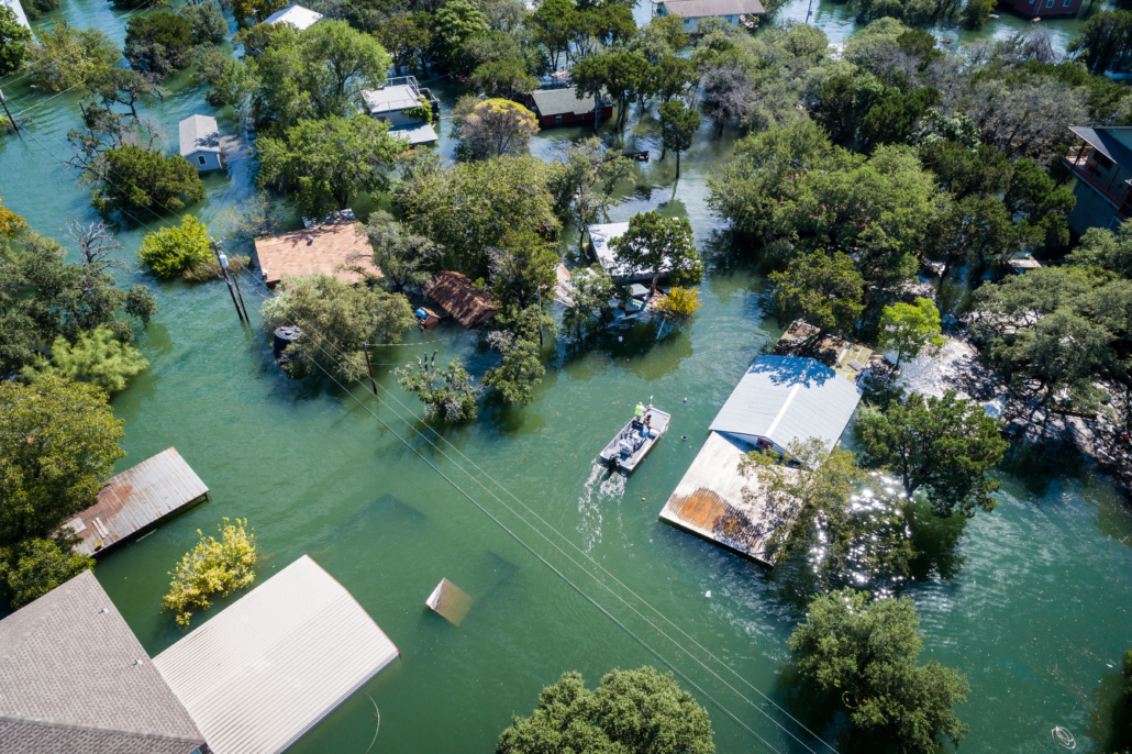
What can drone imagery do for disaster response?
Still Image Survey
A drone survey for disaster response refers to the use of a drone to capture aerial data with downward-facing sensors, such as RGB or thermal payloads. During a drone survey with an RGB camera, the ground is photographed multiple times and each image is tagged with coordinates.
After flight, these photos are processed in photogrammetry software such as PIX4D or Agisoft Metashape. The photogrammetry software can then recreate geo-referenced 3D maps, contour lines, digital terrain models, or digital surface models to be reviewed in geospatial software such as ArcGIS or QGIS.
Live Video
When environmental disasters strike, the first 72 hours are critical. The more information responders know about the changing environment the better. Live aerial view from gimbaled EO/IR (visible and thermal video) cameras can reveal current conditions on the ground, giving responders the information they need to respond.
What makes a drone the best option for disaster response?
A drone can safely fly at very low altitudes and in dangerous areas providing the aerial perspective first responders need without risking manned aircraft or taking them from other duties only they can perform. A drone is an affordable solution to provide to smaller units and doesn’t require extensive upkeep or ongoing training like other forms of aviation.
Injured hiker being placed on a gurney.
Search and Rescue (SAR)
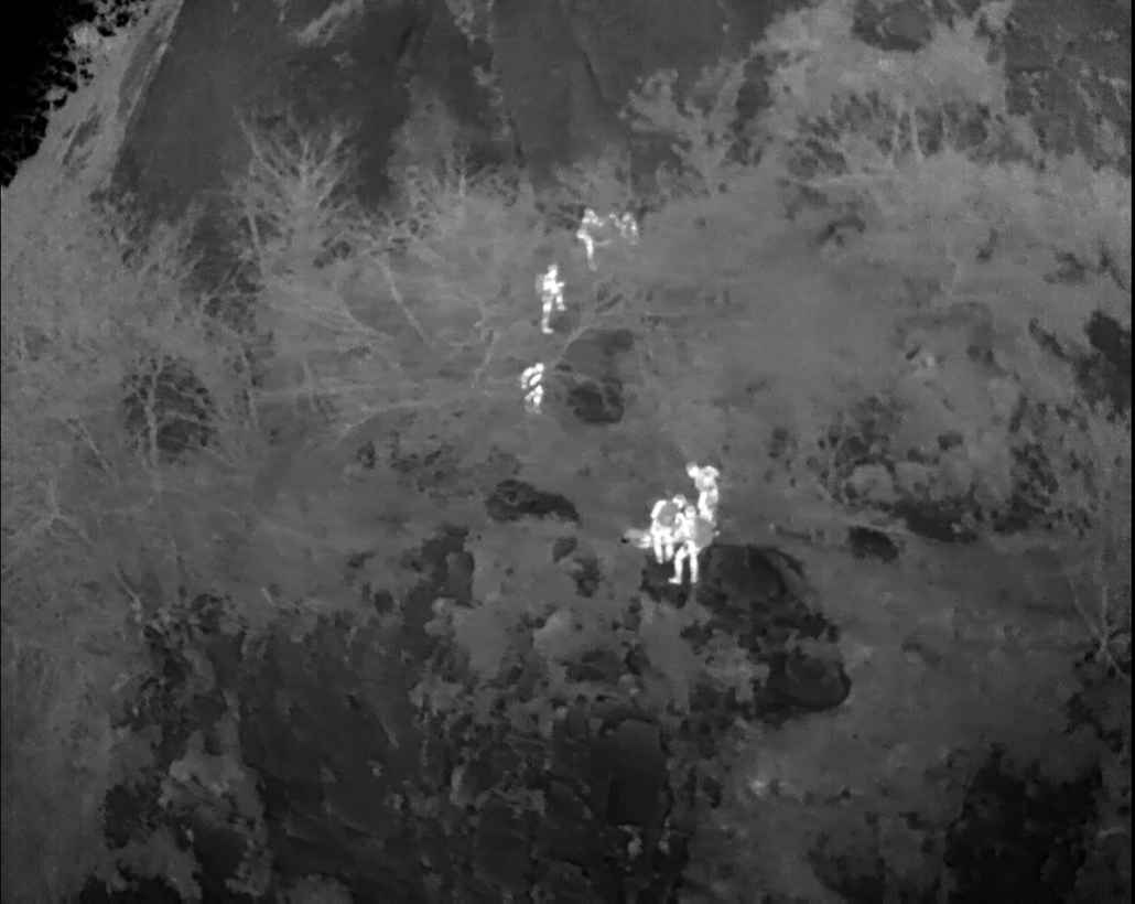
How can a drone help my SAR mission?
In the world of search and rescue, time is your most valuable resource. In most SAR missions, the missing person is trapped in a life-threatening situation. Sometimes for several hours before a rescue team is able to arrive at the scene. A drone can cover a large area much faster than a person on the ground, including remote areas that are difficult to reach on foot. By narrowing down the search area, the chances of rescuing the missing person are increased exponentially.
How can a drone adapt to harsh SAR environmental conditions?
It’s common for SAR missions to take place during times of natural disaster. During these times, weather conditions can make it unsafe for manned aircraft to fly. While multirotor drones also struggle in poor weather conditions; fixed-wing drones are more stable while also removing manned pilots from danger.
The needs of a given search and rescue operation can change dramatically depending on a variety of factors. In cooler weather, thermal imaging is ideal for quickly locating the body heat of a person, but if temperatures soar, high-resolution photography might be a better option. Search and rescue teams need to be able to adapt at a moment’s notice if circumstances change. It’s crucial for SAR drones to have the ability to carry multiple different types of payloads and have the ability to perform day and night operations.
Wildfire Fighting
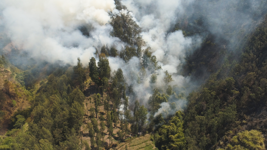
How can a drone help put out wild fires?
With the ever increasing damage from wildfires, the U.S. Department of the Interior and other agencies have turned to drones to help extinguish wildfires, quantify the damage, and plan for rehabilitation.
Live Video
A drone equipped with an EO/IR (Electro-Optical/Infra-Red) camera has the ability to send live thermal data along with coordinates to the main command station for the fire chief to assess. By monitoring the edge of the fire as well as the hot spots inside the fire, a fire chief has the ability to better direct ground crew as well as air attack units attempting to halt the spread of the fire.
Still Imagery
The vast damage that a wildfire creates is extremly hard to quantify with anything except aerial imagery. Smoke can sometimes linger for up to two to three weeks making photography from manned aircraft unviable. Drones have the ability to fly at lower altitudes, avoiding much of the smoke, allowing expedited creation of maps in order to plan a recovery roadmap or perform root cause analysis.
News
 Event 38’s E455 Supports U.S. Army Training Exercise in AlaskaFebruary 3, 2026 - 11:24 am
 Event 38 Integrates CENTUM’s Lifeseeker Mini S10 on the E455 Heavy-Lift VTOL PlatformJanuary 19, 2026 - 10:14 am
 Event 38’s E455 Drone Supports Los Alamos Researchers in Locating Oil and Gas WellsDecember 18, 2025 - 12:02 pm
 Event 38 Featured in World Pipelines MagazineSeptember 16, 2025 - 2:14 pm