New Analysis Tools Available Now In DDMS™ Map Viewer
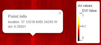
Two new tools are now available to all Drone Data Management System™ users. As part of the Map Viewer data analysis suite, users will now see a legend appear next to maps where an underlying data layer is present. NDVI, DVI and DEM layers show their scale of values and corresponding colors for easy interpretation of each layer. In addition, for the NDVI and DVI layers, clicking on the map at any location will also reveal a popup with GPS coordinates and exact data values.
These features are automatically available to all users processing NDVI, DVI or DEM data.