Description
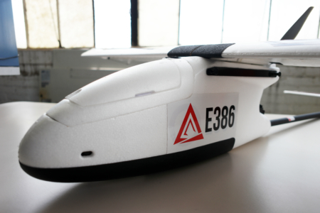
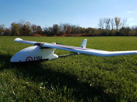
The E386 Fixed Wing Drone is a portable, long endurance mapping drone with short field take-off and landing capability. The E386 makes it easy to collect large high resolution maps. Everything from mission planning to image tagging has been streamlined for this purpose. No separate launch or recovery equipment needed.
Specifications:
- Dimensions: 190cm Wingspan, 130cm Length (75 x 51 inches)
- Wings and body disassemble for easy transport
- Weight: 2.5kg (5.6 lbs)
- Endurance: 85 minutes flight time
- Cruise Speed: 12m/s (27 mph)
- Range: 60km (37 miles)
- Map up to 850 geo-referenced acres per flight at 120m AGL
- Max Payload: 500g (1.1 lbs)
- Automatic lens protection for landing
- Automatic parachute landing
- Complete mission planning and operations software
- For your Windows 7, 8 or 10 laptop (not included)
- Autonomous flight, Return-to-launch, Automated pre-flight checklists, much more
- Operating Conditions
- MSL Ceiling: 3,960 meters, (13,000 ft), – auto take-off tested to 3,100 meters, (10,000 ft)
- Max sustained wind speed: 10 m/sec, (22 mph) for autonomous operation
- Telemetry Range: 5 km+ (3.1 mi)
Camera Options:
There are two standard RGB camera options for the E384: The the Sony R10C and RX1R II. All cameras include an automatic hatch mount and utilize Intellishoot, which automatically takes pictures at optimal overlap to maintain consistency and eliminate redundant data collection. The major differences in these cameras are as follows.
- Sony R10C – 20.1MP Resolution, Landscape Orientation for Maximum Efficiency, PPK Compatible, Full Power Provided by Aircraft
- Sony R10C Plus Companion Computer – Automatically geotags images in real time and uses camera feedback to improve geotag accuracy. Images are stored with geotags in EXIF data and can be imported directly into any photogrammetry software, bypassing the normal geotagging process.
- Sony RX1R II – 42MP Full Frame Exmor R BSI CMOS Sensor, PPK Compatible, Supplementary Power from Aircraft. Currently only compatible with E384-Heavy configuration.
Other camera options are available for specialty applications, please contact us for more information.
- Customized Canon Powershot S110 with infrared filters specifically designed to measure NDVI. Using ratios of visible light to infrared light, we can calculate NDVI, which allows for the detection of crop health.
- MicaSense RedEdge
- Parrot Sequoia
- FLIR Vue Pro
Parachute Recovery
The E386 is designed to be recovered by parachute. The parachute allows the E386 to descend almost straight down at a safe speed of 15 feet per second. When taking wind into account, the E386 can be recovered in an area as small as a 30 meter diameter circle. The parachute is deployed through a command that can be pre-programmed into a mission for completely hands-off flying. The Iris parachute and Harrier launch system from FruityChutes offer lowest weight and easiest to pack system we’ve tested for light UAS. The kit includes a packing tool and packing instructions for a reliable deployment every time.
PPK Precision Geotagging Option
Event 38 offers two PPK GPS options integrated with the E386. The Emlid Reach PPK GPS is an L1-only receiver that enables data collection at centimeter level precision without ground control points. See our case study to read more about the system’s real world accuracy tests. A dual frequency L1/L2 PPK GPS receiver made by Event 38 and powered by Piksi Multi is also available. The accuracy of both systems is comparable. The main advantage of upgrading to L1/L2 is to improve time to first lock and Q1 solution reliability levels.
Both systems include:
- Integration of precision timing on the R10C or RX1R II camera
- GPS receiver with integration with an E384/6
- Antenna and ground plane installation on the E384/6
- Image utility to augment RTKLIB post-processing
PPK GPS systems require a receiver both on the aircraft as well as one in a fixed location on the ground to provide corrections. Both systems are compatible with all known survey-grade GPS receivers, as long as they are able to save raw observation files in Rinex format. In certain areas, you may be able to use publicly available base stations such as the CORS Network in the United States. We recommend the Reach RS+ base station for L1-only systems. We do not currently offer any L1L2 base station receivers.
Package Includes:
- Complete, Flight Tested Autonomous E386 Drone
- Powered by Pixhawk 2.1 Flight Controller
- Flight Planning and Control Software for Autonomous Flight (Includes GPS and Flight Data Log)
- Professional Handheld Remote Controller
- Long Range Ground Station Monitoring and Command Radio
- 1 Flight Battery and Rapid Charger – 4 Cell, 8.0 Ah LiPo
- Online Operations Manual

