How using a drone can reduce man-hours at a quarry or mine.
Our customer, a sand quarry in southern Ohio, was looking for a more efficient way to conduct volumetric analysis of quarry stockpiles. They had a few specific goals:
- They wanted to cut down on the number of hours it took to gather and process the data to calculate stockpile volumes.
- They didn’t want to cut corners and sacrifice data accuracy.
Read on to discover how our customer achieved a 60% reduction in the man hours required to monitor their stockpile volumes by using an Event 38 drone.
Walking the piles: Manual stockpile volume data collection at a sand quarry.
Before working with Event 38, a sand quarry employee would “walk the piles.” In other words, someone would load up a backpack with an RTK GPS receiver and visit every pile in the quarry. That person would walk the perimeter of each pile, climb to the top, and walk across the flat area. This was an eight-hour process.
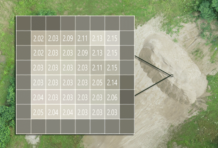
An analyst would then calculate pile volumes by processing all raw GPS data through Carlson Civil Suite. The analyst would estimate the shape and volume of each pile. You can see a sample image and measurement density below. This was a two-hour process for an area of 50 to 75 acres.
Total man hours: 10.
Using a drone to measure stockpile volumes faster.
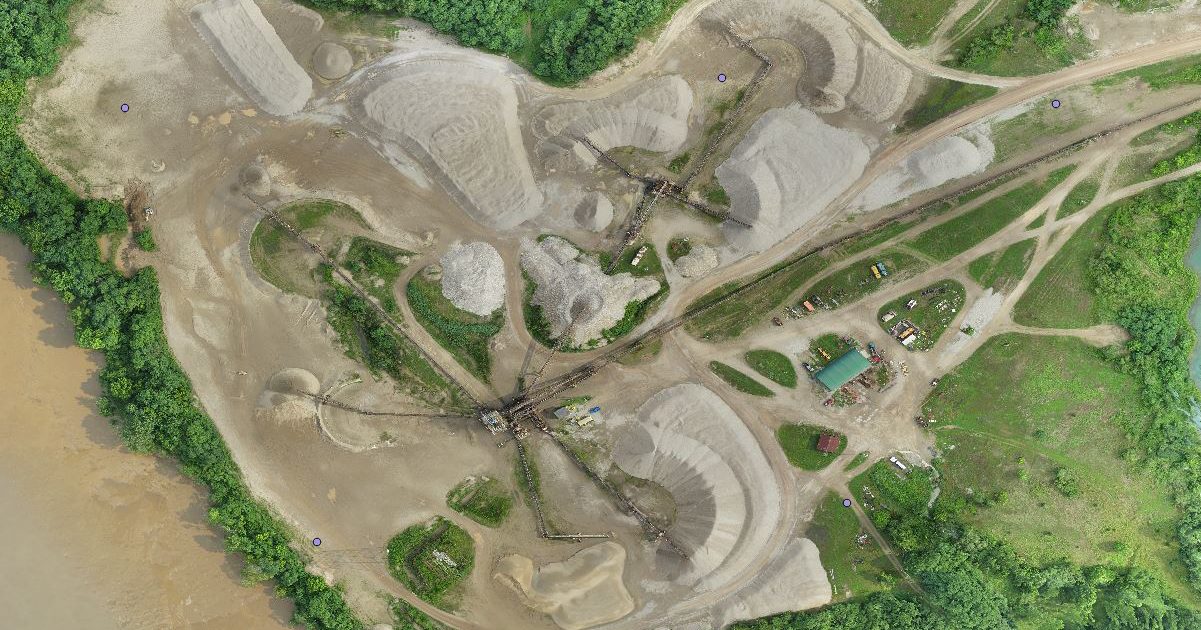
In 2016, the customer bought an Event 38 drone, the E384, to monitor stockpile volumes. (The E384 is now retired.) The drone was outfitted with an S110 camera to collect high-resolution imagery.
The new process starts with operators dropping GCPs (ground control points) at strategic locations throughout the quarry and recording their coordinates with an RTK GPS receiver. The Event 38 drone flies a pre-programmed mission to survey stockpiles and collect data. The same mission plan is often used repeatedly without any need for modification. This is a three-hour process.
All raw image data, from the camera and the drone’s flight telemetry logs, is processed through Event 38’s Drone Data Management System™ (DDMS™):
- DDMS™ reconstructs a three-dimensional model of the terrain using the Digital Elevation Model (DEM) app and thousands of data points collected by the Event 38 drone.
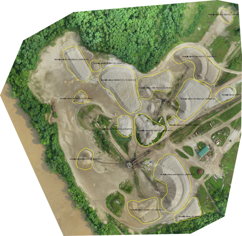
- An analyst or other operator uses Map Viewer to outline the base of each area or pile to be measured.
- The Volume App estimates the elevation and slope of the ground beneath a pile. The Volume App then uses the DEM to calculate the relative height of the pile at each data point throughout the designated area.
- Relative height data is organized into a nine-centimeter grid that represents the designated area, with about 121 data points per square meter. The concentration of data points and the dimensions of the grid will differ based on the application.
- Using these data points, DDMS™ calculates the total volume of the sand pile.
This process requires less an hour of an analyst’s time. DDMS™ spends an additional four hours processing the data. Processing time will vary depending on the area of land surveyed and internet speed.
Total man hours: 4.
The results: How accurate is the data?
We compared each method’s final calculations for one pile:
| Data capture technique | Processing Tool | Volume (cubic yards) |
|---|---|---|
| “Walking the piles” with an RTK GPS receiver | Carlson Civil Suite | 1336.60 |
| Event 38 drone and GCPs | Event 38 DDMS™ | 1315.32 |
Using an Event 38 drone and DDMS™ resulted in a volume measurement within 1.59% of the previous “walking the piles” technique.
This customer always uses GCPs to increase the accuracy of their data collection. But there’s a backup option: Event 38 drones are equipped with an Intellishoot system that administers GPS tags from the air. For the sake of science (and our own curiosity), we processed the data again using just the Intellishoot GPS data, without any help from the GCPs. Here are the results:
| Data capture technique | Processing Tool | Volume (cubic yards) |
|---|---|---|
| “Walking the piles” with an RTK GPS receiver | Carlson Civil Suite | 1336.60 |
| Event 38 drone and GCPs | Event 38 DDMS™ | 1315.32 |
| Event 38 drone and Intellishoot onboard GPS (no GCPs) | Event 38 drone and Intellishoot onboard GPS (no GCPs) Event 38 DDMS™ | 1293.32 |
Using an Event 38 drone and the Intellishoot system resulted in a volume measurement within 3.24% of the previous “walking the piles” technique. We repeated this process on a few more data sets and found a maximum discrepancy of 4.95%, with an average discrepancy of 2.80%. Here is the data:
| (Cubic Yards) | Pile 1 | Pile 2 | Pile 3 | Pile 4 | Pile 5 | Pile 6 |
|---|---|---|---|---|---|---|
| Measured w/GCP | 6967.03 | 1471.66 | 625.45 | 18124.45 | 12154.79 | 19816.06 |
| w/o GCP | 7169.45 | 1438.26 | 637.00 | 17574.68 | 11934.07 | 20792.90 |
| Error | -2.91% | 2.27% | -1.85% | 3.03% | 1.82% | 4.93% |
That being said, collecting drone data with the support of strategically placed ground control points (GPCs) can improve the accuracy of volumetric measurements. If possible, GPCs should be marked permanently to save time and ensure consistency.
The results: Did a drone make a difference?
By using an Event 38 drone and DDMS™, our customer achieved a 60% reduction in the man hours required to monitor their stockpile volumes.
Here’s how the data breaks down:
- Collecting raw data by “walking the piles” takes eight man-hours. Collecting raw data with an Event 38 drone takes three man-hours.
- Processing raw data with Carlson Civil Suite takes two man-hours. Processing raw data with DDMS™ takes less than one man-hour.
- The old method requires a total of ten man-hours. The new method, using an Event 38 drone, requires less than four man-hours.
If you’d like to speak directly to an engineer about buying an Event 38 drone, contact us here.


